Cher (fiume)
Coordinate: 47°20′33″N 0°28′50″E / 47.34250°N 0.48056°E / 47.34250; 0.48056 Lo Cher è un fiume della Francia centrale. È un affluente di sinistra del fiume Loira. Scorre attraverso diverse regioni della Francia. I dipartimenti Cher e Loir-et-Che…
Coordinate: 47°20′33″N 0°28′50″E / 47.34250°N 0.48056°E / 47.34250; 0.48056
Lo Cher è un fiume della Francia centrale. È un affluente di sinistra del fiume Loira. Scorre attraverso diverse regioni della Francia.
I dipartimenti Cher e Loir-et-Cher prendono il nome da questo fiume.
Galleria di immagini
7 Immagini


Geografia
Lo Cher è lungo 367,8 chilometri (228,5 miglia). Il suo bacino di drenaggio copre 13.920 chilometri quadrati (5.375 miglia quadrate).
La sua portata media annuale (volume d'acqua che passa attraverso una sezione del fiume per unità di tempo) è di 92,60 m3/s (3.270 cu ft/s) a Tours, Indre-et-Loire (1966 - 2017), vicino alla sua bocca.
![]()
Scarico medio mensile (m3/s) a Tours
Corso
Lo Cher inizia nel Massiccio Centrale, nel comune di Mérinchal, dipartimento della Creuse, regione della Nouvelle-Aquitaine. Inizia ad un'altitudine di circa 715 metri.
Lo Cher scorre, in generale, verso nord-ovest. Attraversa le seguenti regioni, dipartimenti e comuni:
- Regione Nouvelle-Aquitaine
- Creuse: Auzances.
- Regione Auvergne-Rhône-Alpes
- Puy-de-Dôme: Château-sur-Cher.
- Allier: Montluçon, Vallon-en-Sully, Meaulne.
- Regione Centro-Val de Loire
- Cher: Ainay-le-Vieil, Bouzais, Saint-Amand-Montrond, Châteauneuf-sur-Cher, Colombiers, Corquoy, Crézançay-sur-Cher, Drevant, Épineuil-le-Fleuriel, Farges-Allichamps, Foëcy, La Groutte, Lapan, Lunery, Méry-sur-Cher, Nozières, Orval, La Perche, Quincy, Saint-Florent-sur-Cher, Saint-Caprais, Saint-Georges-de-Poisieux, Saint-Georges-sur-la-Prée, Saint-Loup-des-Chaumes, Thénioux, Vallenay, Venesmes, Vierzon
- Loir-et-Cher : Angé, Bourré, La Chapelle-Montmartin, Châtillon-sur-Cher, Châtres-sur-Cher, Châteauvieux, Couddes, Faverolles-sur-Cher, Gièvres, Mareuil-sur-Cher, Mennetou-sur-Cher, Monthou-sur-Cher, Montrichard, Pouillé, Selles-sur-Cher, Saint-Aignan, Saint-Georges-sur-Cher, Saint-Julien-sur-Cher, Seigy, Thésée, Villefranche-sur-Cher.
- Indre : Chabris
- Indre-et-Loire : Athée-sur-Cher, Azay-sur-Cher, Bléré, Chenonceaux, Chisseaux, Civray-de-Touraine, La Croix-en-Touraine, Dierre, Larçay, La Riche, Saint-Avertin, Saint-Genouph, Savonnières, Tours, Véretz, Villandry.
Alla sua fine, lo Cher sfocia nel fiume Loira al bec du Cher ("becco dello Cher") nel parco naturale regionale Loire-Anjou-Touraine (Parc naturel régional Loire-Anjou-Touraine) a Villandry. Si trova a circa 20 chilometri a ovest della città di Tours, nel dipartimento Indre-et-Loire, a 38 metri di altitudine.
Affluenti principali
I principali affluenti, con una lunghezza superiore a 50 km, del Cher sono:
| Affluenti di sinistra:
| Affluenti di destra:
|
Galleria
· 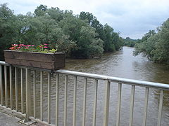
Lo Cher a Villeneuve-sur-Cher.
· 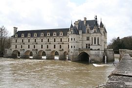
Château de Chenonceau sul fiume Cher.
· 
Ponte sullo Cher a Saint-Florent-sur-Cher.
· 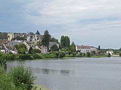
Il fiume Cher a Saint-Aignan.
· 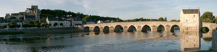
Il fiume Cher a Montrichard.
Pagine correlate
Domande e risposte
D: Quali sono le coordinate del fiume Cher in Francia?
R: Le coordinate del fiume Cher in Francia sono 47°20′33″N 0°28′50″E / 47.34250°N 0.48056°E / 47.34250; 0.48056.
D: Che tipo di fiume è lo Cher?
R: Lo Cher è un affluente di sinistra del fiume Loira.
D: Quali regioni della Francia attraversa il fiume Cher?
R: Il fiume Cher attraversa diverse regioni della Francia.
D: Quali dipartimenti prendono il nome dal fiume Cher?
R: I dipartimenti Cher e Loir-et-Cher prendono il nome dal fiume Cher.
D: Il fiume Cher si trova nel nord della Francia?
R: No, il fiume Cher si trova nella Francia centrale.
D: Il fiume Cher confluisce nel fiume Loira?
R: Sì, il fiume Cher è un affluente di sinistra del fiume Loira.
D: Qual è l'importanza del fiume Cher in Francia?
R: Il fiume Cher è così importante da avere due dipartimenti, il Cher e il Loir-et-Cher, che prendono il suo nome.
Articoli correlati
Autore
AlegsaOnline.com Cher (fiume) Leandro Alegsa
URL: https://it.alegsaonline.com/art/19253
Fonti
- commons.wikimedia.org : Cher river
- services.sandre.eaufrance.fr : "le Cher (K---0090)"
- hydro.eaufrance.fr : "Le Cher à Tours (Pont Saint Sauveur)"
- geoportail.gouv.fr : "Source de le Cher"
- geoportail.gouv.fr : "Confluence de le Cher"
- services.sandre.eaufrance.fr : "Fiche cours d'eau: la Tardes (K51-0300)"
- services.sandre.eaufrance.fr : "Fiche cours d'eau: l'Arnon (K6--0240)"
- services.sandre.eaufrance.fr : "Fiche cours d'eau: le Fouzon (K65-0300)"
- services.sandre.eaufrance.fr : "Fiche cours d'eau: l'Aumance (K53-0300)"
- services.sandre.eaufrance.fr : "Fiche cours d'eau: l'Yèvre (K5--0230)"
- services.sandre.eaufrance.fr : "Fiche cours d'eau: la Sauldre (K6--0250)"